A few years ago Dan Reilly, the warning coordination meteorologist at the local National Weather Service, and I were discussing fall cool fronts. The first day it truly felt like fall in Houston should be a holiday, we agreed. Every year since, Space City Weather has designated the first day it will truly feel like “fall” in Houston as Fall Day. This year, that day comes on Wednesday, after a front moves through overnight and brings much cooler and drier air to the region. It may not be an official holiday, but it sure should be one after we survive summer.
Monday
Before we get to the front, however, Houston will experience a little bit more heat. Highs today should reach at least the low 90s, with sunny skies. Rain chances are essentially zero north of Interstate 10, and perhaps 10 to 20 percent closer to the coast. Winds will be light, out of the southwest, at 5 mph. Conditions overnight will be warm and muggy.
Tuesday
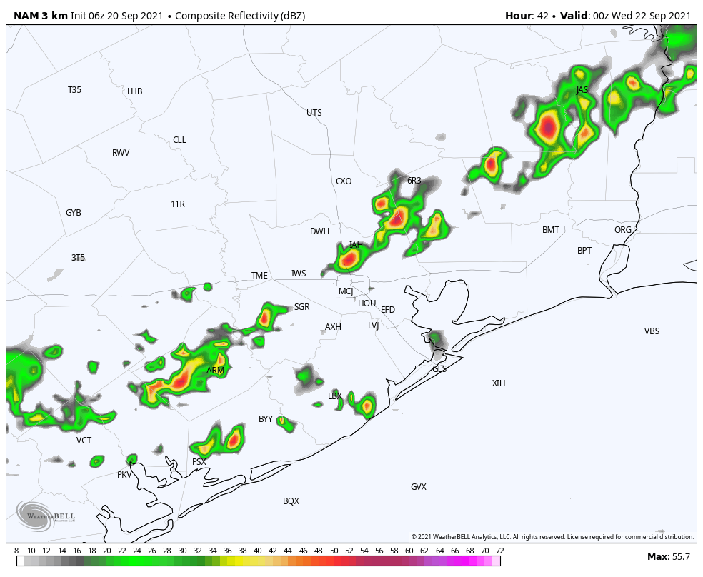
This will be another hot, humid, and sunny day in Houston, but it will be the last one for awhile. That’s because a bona fide front will push through Houston. The timing is a bit uncertain yet, but expect a broken line of showers and thunderstorms to reach central Houston perhaps around sunset, and push off the coast during the late evening hours. After this, drier air will move into the region during the overnight hours. Most of the region should wake up Wednesday morning to dewpoints in the 50s.
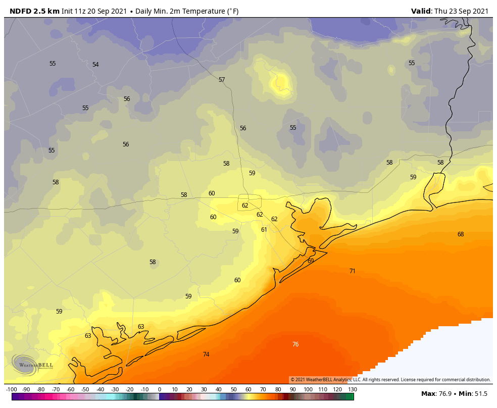
Fall Day
This will be a fine day, with sunny skies, moderate northerly winds of 10 to 15 mph, and highs in the low 80s. As the sun drops toward the horizon, so too will temperatures. Inland lows likely will reach the upper 50s, with areas closer to the coast staying in the low 60s.
Thursday and Friday
These should be sunny, pleasant days with highs in the low 80s, and overnight lows down around 60 degrees.
Saturday and Sunday
We should see some warming over the weekend, but even with mostly sunny skies I don’t think highs will get above the mid- to upper-80s. Dewpoints will remain lower than summertime levels, so while it won’t be cold, it won’t be unpleasantly steamy, either.
Tropics
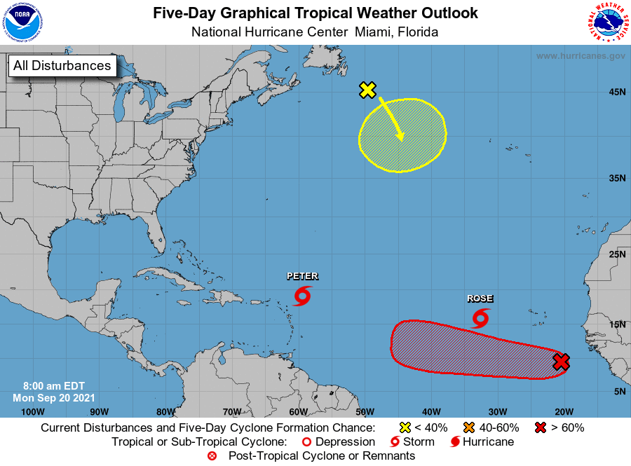
Call it the Charlie Hustle tropics forecast, with Peter and Rose active in the Atlantic Ocean. Fortunately, neither storm presents a significant threat to any landmasses. Beyond this, the red X off the coast of Africa could very well develop as it moves west across the Atlantic Ocean. This system seems unlikely to be bound for the Gulf of Mexico, however. Overall, in fact threats to the Gulf over the next 10 days are fairly low. I’m not complaining.
Huzzah! I am on board with “Fall Day” as our local holiday! And, Wednesday is the first day of autumn, too.
Thanks to Eric and Matt for putting on their weather wizard hats and making this happen. (Of course, they can’t conjure up the weather, though it is a nice fantasy.)
Suspect a cold front arriving on the first day of autumn hasn’t happened here very often!
Hurricane Nicholas might have been the season finale for TX Hurricane season with this front coming through.
It’s great to see you guys coming around with the idea of a Fall Day. For 12 years now, our family and some friends have celebrated this event (called “Autumnus Maximus”) by grilling steaks/shriimp and having a nice cold one. We even have a flag we put up. Defined as the first day of highs only in the 70s or lows in the 50s. Happy Autumnus Maximus!
Hooray for FALL DAY!! What a difference a week makes:)
Wednesday IS “Fall Day”! 2:21 pm is the equinox. 🙂
Based on prior posts I’ve read here on SCW, after the first cold front pushes through Texas, the chances of a hurricane hitting the Texas coast drop way down (but are not zero).
I’m not familiar with why. Is this based on historical data (i.e. a lack of precedent), or is this based on some meteorological principal? Maybe that would be a good topic for a post tomorrow or after this year’s Tropical Updates are over?
As the climate continues to warm, is this another weather pattern that could be altered as well?
I don’t see a reply but I will take a stab at it…cold fronts are anchored to the north by low pressure systems, which typically move west to east. Lows follow lows. So hurricanes will be drawn to the NE by the anchoring low. After the first deep front of the season the fronts typically start arriving every 7 days or so. In fact another front is in the forecast 7 days or so after this one.
The danger for us is if a low forms in the “tail” of the current front. If this low forms over water it can quickly turn tropical.
Hope the power plants can keep up with the cold weather …
What is dewpoint? I see mentions of it all the time, but I don’t really understand what ieand.
Thanks.
Without getting into enthalpy and thermodynamics, the dewpoint is the temperature the air must reach for condensation to occur, so it is a measure of the amount of moisture in the air; a lower dewpoint means less moisture (so less humidity).
Love the Charlie Hustle….but it shows your age….guess it shows mine too.
Temperatures of around 80 for the high and lows around 60 is not chilly at all. I’ve lived in places where summer days are mostly in the low 80s and summer nights in the low 60s quite often.
Well, I don’t know about you, but after a long summer when I go out in the daytine and temperatures are below 80 I find myself saying, “Is it allowed to be this cool out?”
Fall Day, let’s goooooooooooo
My favorite holiday is Fall Day! I agree, let’s make it official!
Your tropics forecast took me straight back to Philadelphia and the 1980 World Series. Pete Rose, Mike Schmidt, Steve Carlton, Tug McGraw. Thanks for the trip down Memory Lane!
We don’t want to be Ray Fosse to Pete’s Charlie Hustle, to continue the tropics metaphor.
Aaaaahh! You’re old!! Charlie Hustle…good one!
“Fall Day” falling on the equinox is exceedingly cool!
I am going to picky here. Charlie Hustle is not Peter Rose. Charlie Hustle is Pete Rose.. Peter Rose (Jr.) is the son of Charlie Hustle also known as Pete Rose.
I am mistaken. I am sorry. Charlie Hustle is Peter Rose.
I think you’re right about being designated a holiday. Last Saturday though I found myself a mere 75 miles north of Houston and woke up to a very refreshing 55°. That was a truly a blessing.
It should be a grand day for a party. It’s also Hobbit Day. https://en.m.wikipedia.org/wiki/Hobbit_Day
Ha! Love your “Pete “Rose” reference! Y’all do a Fine Job for us in the Houston Area. 👍❤🍂😊🍁